Microsoft announces Bing Maps V8 August 2016 Update with new map styles and more
3 min. read
Published on
Read our disclosure page to find out how can you help MSPoweruser sustain the editorial team Read more

Microsoft today announced the release of second monthly update to Bing Maps Version 8 control (V8) since its release. Many new features such as draggable pushpins and spatial math geometry were added as part of last month update. This month update includes 30+ bug fixes and several new features. Also, the TypeScript defintions have been updated and are also now availabble as an npm package. Find the full list of new features below.
What’s New:
Animated Tile Layers
Makes it easy to smoothly animate through and array of tile layers. Try it now
High Contrast Support
To make Bing Maps more accessible, high contrast support has been added. When the user’s computer is in high contrast mode, a high contrast version of the road maps will be displayed.
New Road Map Styles
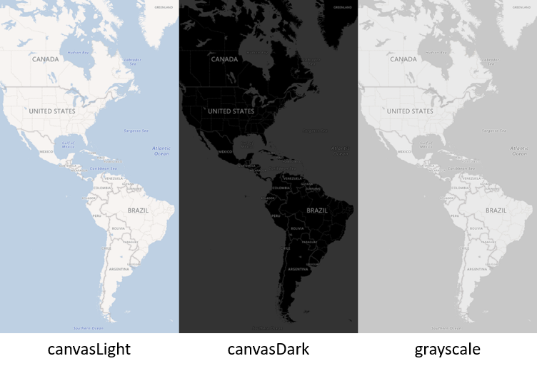
Three new road map styles have been added; grayscale, canvasDark and canvasLight. These are designed to make it easy to focus on the data you overlay on top of the map and are much better suited for business intelligence type scenarios than the default road map style. You can find documentation here.
Infobox improvements
The infobox class now supports HTML descriptions values. The infobox class also automatically scales to fit it’s content. Maximum width and height values can be specified. Try it now
Polygon & Polyline generalization
By default polylines and polygons are generalized (simplified) when rendered based on the current zoom level. This provides a performance enhancement when these shapes have more than just a few locations in them. If you are working with a lot of simple shapes (i.e. triangles) cosider disabling this feature by setting the
generalizableoption of the shape to false as this optimization will not provide any benifit in this case.DrawingTools improvements
The DrawingTools class has had a number of improvements which make it much easier to create individual shapes and attach events to them.
Disable Streetside options
There are two new map options for disabling streetside functionality. The first,
disableStreetside, completely disables this feature and removes it as an option in the navigation bar. The second,disableStreetsideAutoCoverage, disables the automatic streetside coverage layer that appears when zoomed in at lower zoom levels.Microsoft Maps CSS namespacing
All CSS classes used by the Bing Maps V8 SDK have been namespaced with a MicrosoftMaps namecpace to reduce the likelihood of naming collisions with CSS classes from other libraries.
Read more about it here.


User forum
0 messages