Microsoft announces Bing Maps V8 July 2016 Update
![]() 2 min. read
2 min. read
![]() Published on
Published on
Share this article

Improve this guide
Read our disclosure page to find out how can you help MSPoweruser sustain the editorial team Read more
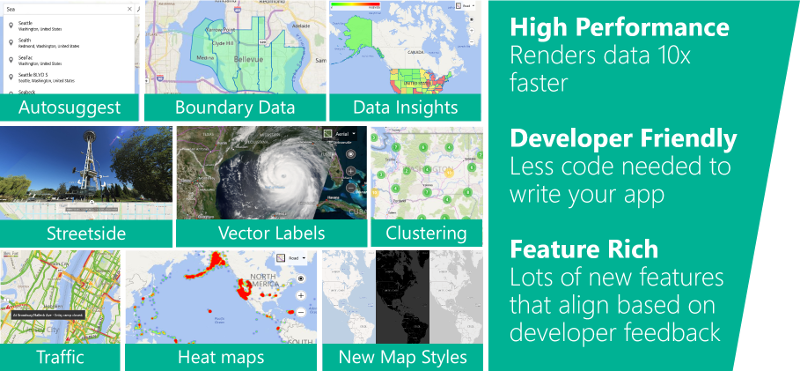
Bing Maps team announced the preview release of the Bing Maps V8 web control few months back at Build developer conference. Back in June, they announced that Bing Maps V8 control is stable and ready for production. The new V8 control allows developers to implement features such as Autosuggest, Streetside imagery and many business intelligence tools using few lines of code. Also, the new V8 control is using the HTML5 canvas for significantly faster performance. Today, they announced the first of their regular updates to the main release branch of V8. This update includes new features and bug fixes.
- Spatial Math Geometry: The Spatial Math module has had a massive addition consisting of 24 spatial geometry calculations, bringing the total number of calculations available in the spatial math module to 47. Some of these calculations include: binary operations of shapes (intersection, difference, union), convex and concave hulls, Voronoi diagrams, shape validation and much more.
- Draggable Pushpins: Easily move drag pushpins around on the map by setting the draggable pushpin option to true.
- Custom Overlays: Custom overlays allow you to create your own custom rendering layers with the map control.
- TypeScript Definitions: Last week we released TypeScript definitions available for Bing Maps V8 on GitHub. You can find the announcement here.
- Clickable Pushpin Area: V8 now lets you specify that a rounded click area should be used instead. Early testing has found that this drastically reduces false clicks on pushpins and thus creates a much better user experience.
- GeoJSON and Query API Shape Styling: Now, with this update, any Pushpin, Polyline or Polygon option can be specified for individual shapes through the shapes GeoJSON properties or as a data source column in the Bing Spatial Data Services.
- Mercator Map Type: Bing Maps provides road and aerial maps which are great in most cases, but sometimes you may want to hide these all together. Perhaps you have your own custom tile layer that you want to display instead, or perhaps you simply want to view your data on its own without a map background. You can easily do this now by setting the map type id of the map to mercator.
- Bug Fixes: Since the initial release of V8 many developers have been proactive in reporting bugs and testing the fixes in the experimental branch. With this release there are over 60 bug fixes.
Check out the Interactive SDK and MSDN Documentation for more details.


User forum
2 messages