GPS Tools got a new version: Added Interface to Wikipedia, Yelp and FourSquare
![]() 4 min. read
4 min. read
![]() Updated on
Updated on
Share this article
Improve this guide
Read our disclosure page to find out how can you help MSPoweruser sustain the editorial team Read more
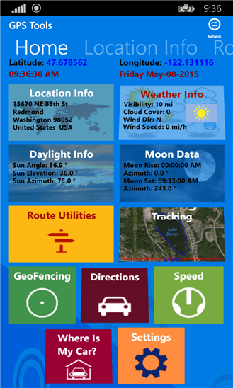
The GPS Tools application added interface to Wikipedia, Yelp and FourSquare. Now the user can get information from these data sources that are related to a GPS location.
The GPS Tools application is a framework of GPS dependent utilities. The application uses the onboard GPS as well as online resources to accomplish its tasks.
The GPS Tools application is divided into these sub-categories:
- Location Information (Coordinates, Addresses & Elevation.
- Select Location
- Display Location information: Address, Coordinates, Elevation and Map
- Share Location (Tweet, SMS, Social Networks)
- Save as a Favorite Location
- Routes Designer
- Define a Route
- Edit a Route
- Calculate a Route length
- Display a Route Elevation Profile vs. Distance
- Calculate a Route area
- Tracking Utilities
- Track phone Location on a Map
- Display elapsed Time
- Display elapsed Distance
- Insert Markers on a map
- Draw tracking chart profile of Time, Distance, Elevation and Speed.
- Display Speed
- Display local Temperature
- Daylight Information
- Select desired date
- Calculate and display Sunrise and Sunset times
- Display Length of Day and Solar Noon time
- Display Twilight and Photography times
- Calculate Sun Angle, Elevation and Azimuth
- Display Daily Sunrise, Sunset and Length of Day chart
- Moon Information
- Select desired Date
- Calculate Moonrise and Moonset and Azimuths
- Calculate Moon Age and Display Moon Phase
- Calculate Full Moon and New Moon dates
- Weather Information
- Display Current Weather conditions
- Display five days of weather projection
- Display five days of hourly weather conditions
- Projection and GeoFence Utilities
- Select any two locations (use the same four location selection methods described below)
- Calculate and draw projected point, based on distance and bearing
- Calculate and Draw GeoFence, based on center and radius
- Save as a Favorite Location
- Directions Utility
- Display directions (Bing driving, walking and transit)
- Get Directions to Favorite saved locations
- Voice navigation interface
- Speedometer Utility
- Display Speed
- Display Distance
- Display Altitude
- Display Elapsed Time
- Display Average Speed
- Select Speed range: Walk, Bike, Car
- Time Zone
- Display the Time Zone value & ID
- Display the Daylight Saving value
- Display a running World Clock
- Display Hours relative to Local Time Zone
- Where Is My Car? A parking utility to mark where your Car is parking
- Display address and coordinates for Car location
- Share the car location
- Display time remaining (or overrun)
- Display walking directions to your Car
- Take a picture of the Car location
- Set Alarm
- Set Toast reminder messages
- Data Utilities
- Export data to Excel for further analysis
- Backup data to OneDrive
- Share data
- About & Setup
- Set Lock screen
- Set Backup/Restore to/from OneDrive
- Set Imperial or Metric Units
- Set Fahrenheit or Celsius
- Set Multiple Area Unit types
- Set Decimal coordinates vs. Deg./Min./Sec. coordinates
- Set Data Filtering
- Set Tracking Trigger Mode, Frequency and Accuracy
- Map Utilities
- Display a scale on the map (scale dynamically changes based on the map zoom level)
- Control Zoom level with a slider
- Fit and Center the Map
- Set multiple map display modes (e.g. Road, Aerial)
- Favorite Location Utilities
- Save a location as a favorite
- Edit / Delete Favorite location
- Import a location from the Phone Contact list
- Get Directions to a Favorite location
- Near By Utilities
- Search for Businesses near your location using Yelp Data
- Search for Businesses near your location using FourSquare Data
- Filter by Distance
- Sort by Name
- Sort by Distance
- Sort by Rating
- Sort by Reviews
- Get Directions to Location
- Wikipedia
- Show Wikipedia entries for location
- Filter by Distance
- Sort by Title
- Sort by Ranking
- Sort by Distance
- Get Directions to Location
The GPS Tools application allows users to select a location (or multiple locations, based on the current application utility) anywhere on the globe in five different ways:
- Current GPS Location
- Location based on Coordinates
- Location based on Address
- Map utility to select location
- Import a location from the Phone Contact list


User forum
0 messages