Measure Distance on Google Maps on iPhone - How-To Guide
The Measure Distance on Google Maps on iPhone enables you to find the shortest or as-the-crow-flies distance between two points on the map. If you’re unfamiliar with how this feature works, this article is just for you! Let’s get started!
What Is Measure Distance on Google Maps?
Measure distance is a Google Maps feature that calculates the straight line distance between two points on the app. You can add as many points as you want to create a non-straight line distance measurement from the starting point to the destination.
This feature is fundamentally different from the automatically calculated distance when you use the Directions feature. While the Directions feature calculates the shortest route between two points involving turns and bends, Measure distance only works in a straight line.
Tips for Measure Distance of Google Maps
- It’s only visible when you drop a pin on an unmarked place on Google Maps.
- You must manually add multiple waypoints between two points avoiding buildings and dead ends. It only shows the displacement between two points.
- It’s available on Google Maps apps on iPhone, iPad, Android, Mac, Windows PC, etc. You can also use it on your browser.
- Measure distance is also available on the Google Earth app.
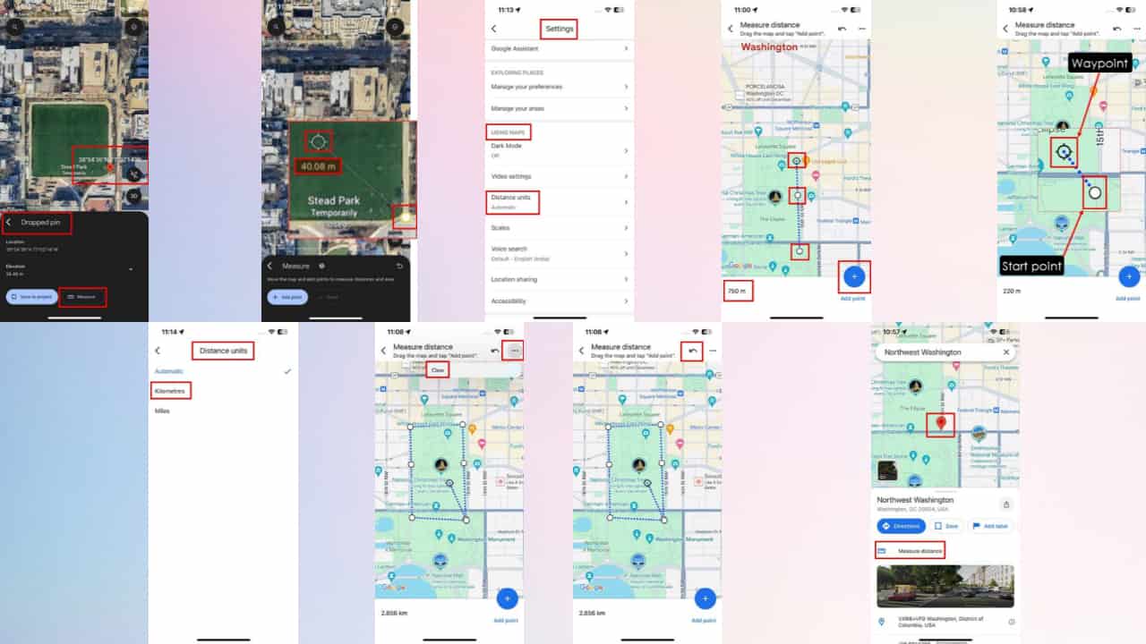
How To Measure Distance on Google Maps on iPhone
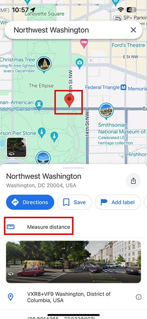
- Tap and hold on to the starting point on the map until a red pin appears. The location shouldn’t be a business or a marked place on the map. If the highlighted place on the map has a name, it’ll show up.
- There, you should see the Measure distance button below the Directions button.
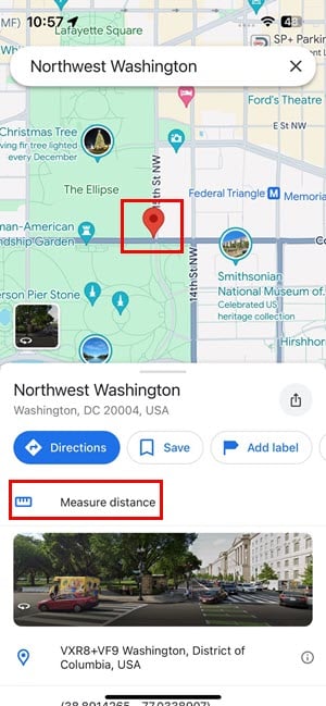
- Tap on the Measure distance button to activate its functionalities.
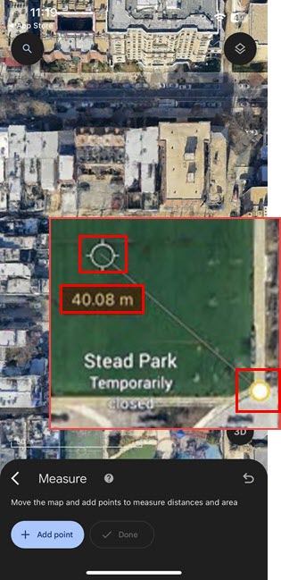
- You’ll see two points on the map.
- The solid white dot is the starting point of the distance being measured.
- The hollow black crosshair is the variable point or the waypoint that you can change.
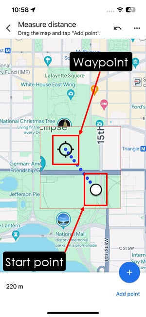
- You can move the map to place the black crosshair on the second point.
- Now, tap on the Add point button in the bottom right corner of the app. The second point will now become another solid white dot.
- This way, you can keep on adding more points on the map for distance measurement purposes.
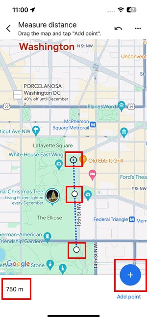
- You should see the total distance in the bottom left corner of the screen.
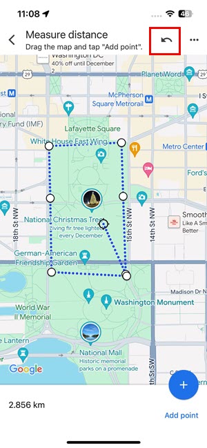
How To Undo Measure Distance Points
If you’ve added a wrong waypoint, you can undo that as well.
There are two undo options. You can remove the recently added waypoint or delete all the waypoints on the map.
- Suppose, you’ve added 8 waypoints so far. You’d like to remove the recent one.
- Press the Undo button in the top-right corner of the Google Maps app.
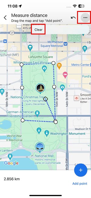
- If you want to remove all the waypoints and start over, tap the ellipses (three dots) icon in the top-right corner of the app.
- Tap on Clear to delete all waypoints.
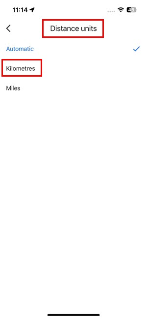
How To Change the Unit of Measure Distance
If you wish to switch between metric and imperial units to measure distance on Google Maps, follow these steps:
-
- Go to the Home Page of Google Maps.
- Tap on your profile picture or avatar in the top right corner of the app.
- Tap Settings on the menu that pops up.
- Under the Using Maps section, tap on the Distance units menu item.
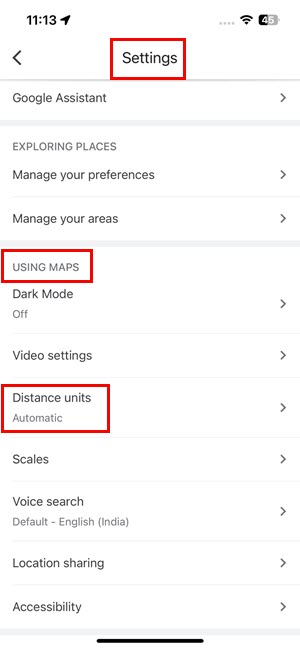
- For the imperial unit convention, choose Miles.
- For the metric unit system, choose Kilometers.
How To Measure Distance on Google Earth on iPhone
- Similar to Google Maps, just drop a pin on an unmarked place on Google Earth.
- Below the Dropped pin message box, you should find Measure beside Save to project.
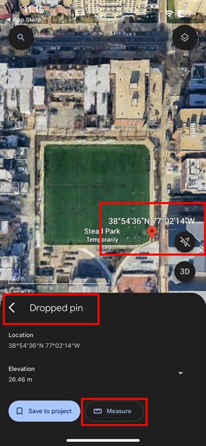
- Tap Measure to add the starting waypoint and the variable crosshair.
Measure on Google Earth is the same as Measure Distance on Google Maps. The only difference is you get a dynamic distance measurement as you place the new waypoints or move the map to position the waypoint.
Further readings:
- Google Maps: How to Find the Flattest Route [Easy]
- How to Find Halfway Point on Google Maps
- How to Remove Labels From Google Maps
So, now you know how to use the Measure Distance on Google Maps on iPhone. Did the article help? Do you know a better way to use Google Maps Measure distance? Share your thoughts and feedback in the comment box below.
Read our disclosure page to find out how can you help MSPoweruser sustain the editorial team Read more


Improve this guide


User forum
0 messages