Google Maps Rolls Out Greener Routes for Europe - Here’s What’s Changing
Google just announced a fresh round of updates for Maps across Europe, aimed at cutting car use and making travel options cleaner and more efficient.
The company is expanding its AI-powered feature that recommends walking or transit if the time is nearly the same as driving. It already works in over 60 cities and has helped avoid tens of millions of car trips. This summer, it’s coming to places like Copenhagen, Stockholm, and Warsaw.
Cyclists in 17 more cities, including Madrid, Milan, Brussels, and Zurich, will now see better route info. This includes data on bike lanes, car traffic, and hills, drawn from local partnerships. In total, Maps now covers over 125,000 kilometers of bike lanes globally.
Other recent Google news –
- Google Drive rolls out Gemini-powered summary cards for PDFs But What’s New?
- Here Are Google’s Top 3 AI Announcements for Android
- Google Meet Just Got Better – You Can Now Style Captions Your Way
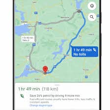
Google’s fuel-efficient routing system is also going global. It calculates routes that burn less fuel or battery, even if they’re not the fastest. The company estimates this option has already prevented over 2.7 million metric tons of emissions this year, the same as taking more than 600,000 gas-powered cars off the road.
For drivers in Europe, low-emission zone alerts are getting a major upgrade. Where Maps already shows alerts in cities like London and Berlin, that number will jump to more than 1,000 zones across Italy, Austria, Sweden, and more.
Google is also scaling up Project Green Light. This tool helps cities adjust traffic light patterns based on real-time driving data. With Vilnius now included, the program operates in 20 cities worldwide.
These updates aim to make the cleaner choice the default for anyone getting around Europe, on foot, by bike, or behind the wheel.
You may also be interested to read –
Read our disclosure page to find out how can you help MSPoweruser sustain the editorial team Read more


Improve this guide
User forum
0 messages