Google announce Google Maps roadmap for 2021
![]() 6 min. read
6 min. read
![]() Published on
Published on
Share this article

Improve this guide
Read our disclosure page to find out how can you help MSPoweruser sustain the editorial team Read more
In a blog post, Dane Glasgow, VP of Google Maps put forward a list of improvements and features coming to their navigation product over the next year.
[lwptoc title=”Google Maps 2021 roadmap” width=”40%” float=”right”]
Google says they are planning to bring over 100 AI-powered improvements to Google Maps to deliver the most accurate, up-to-date information about the world.
Here is a partial list of the updates and improvements coming:
Navigate indoors with Live View
Live View is Google’s tool which lets you understand your orientation by using AI to scan tens of billions of Street View images.. Thanks to new advancements that help them understand the precise altitude and placement of objects inside a building, Google is now able to bring Live View to some of the trickiest-to-navigate places indoors: airports, transit stations and malls.
If you’re catching a plane or train, Live View can help you find the nearest elevator and escalators, your gate, platform, baggage claim, check-in counters, ticket office, restrooms, ATMs and more. Arrows and accompanying directions will point you the right way. And if you need to pick something up from the mall, use Live View to see what floor a store is on and how to get there so you can get in and out in a snap. Indoor Live View is live now on Android and iOS in a number of malls in Chicago, Long Island, Los Angeles, Newark, San Francisco, San Jose, and Seattle. It starts rolling out in the coming months in select airports, malls, and transit stations in Tokyo and Zurich, with more cities on the way.
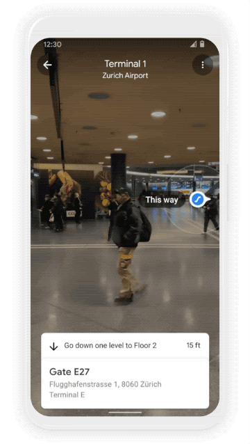
Find your way inside airports, train stations, and malls with Indoor Live View
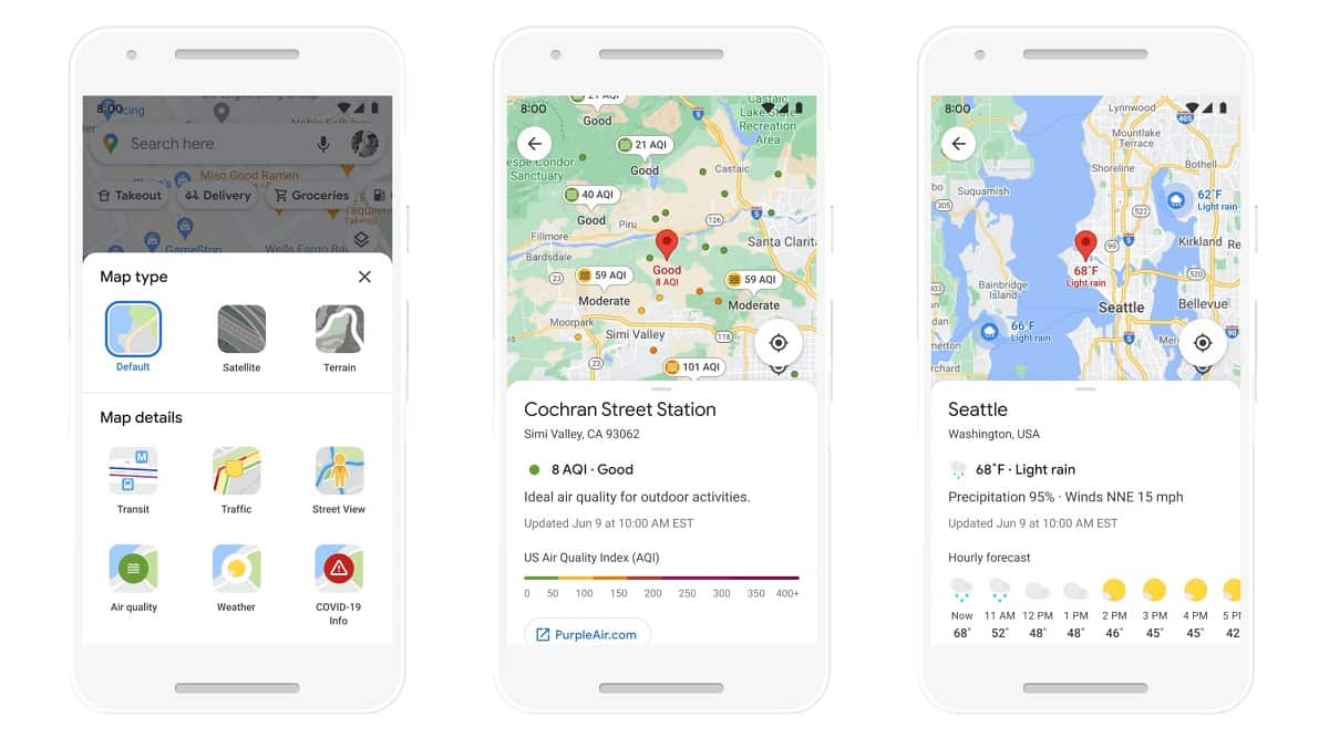
Plan ahead with more information about weather and air quality
With the new weather layer, you can quickly see current and forecasted temperature and weather conditions in an area — so you’ll never get caught in the rain without an umbrella. And the new air quality layer shows you how healthy (or unhealthy) the air is — information that’s especially helpful if you have allergies or are in a smoggy or fire-prone area. Data from partners like The Weather Company, AirNow.gov and the Central Pollution Board power these layers that start rolling out on Android and iOS in the coming months. The weather layer will be available globally and the air quality layer will launch in Australia, India, and the U.S., with more countries to come.

See helpful air quality and weather information with new layers in Google Maps
Find more eco-friendly options to get around
With insights from the U.S. Department of Energy’s National Renewable Energy Lab, Google is building a new routing model that optimizes for lower fuel consumption based on factors like road incline and traffic congestion. Soon, Google Maps will default to the route with the lowest carbon footprint when it has approximately the same ETA as the fastest route. In cases where the eco-friendly route could significantly increase your ETA, we’ll let you compare the relative CO2 impact between routes so you can choose. Always want the fastest route? Simply adjust your preferences in Settings. Eco-friendly routes launch in the U.S. on Android and iOS later this year, with a global expansion on the way.
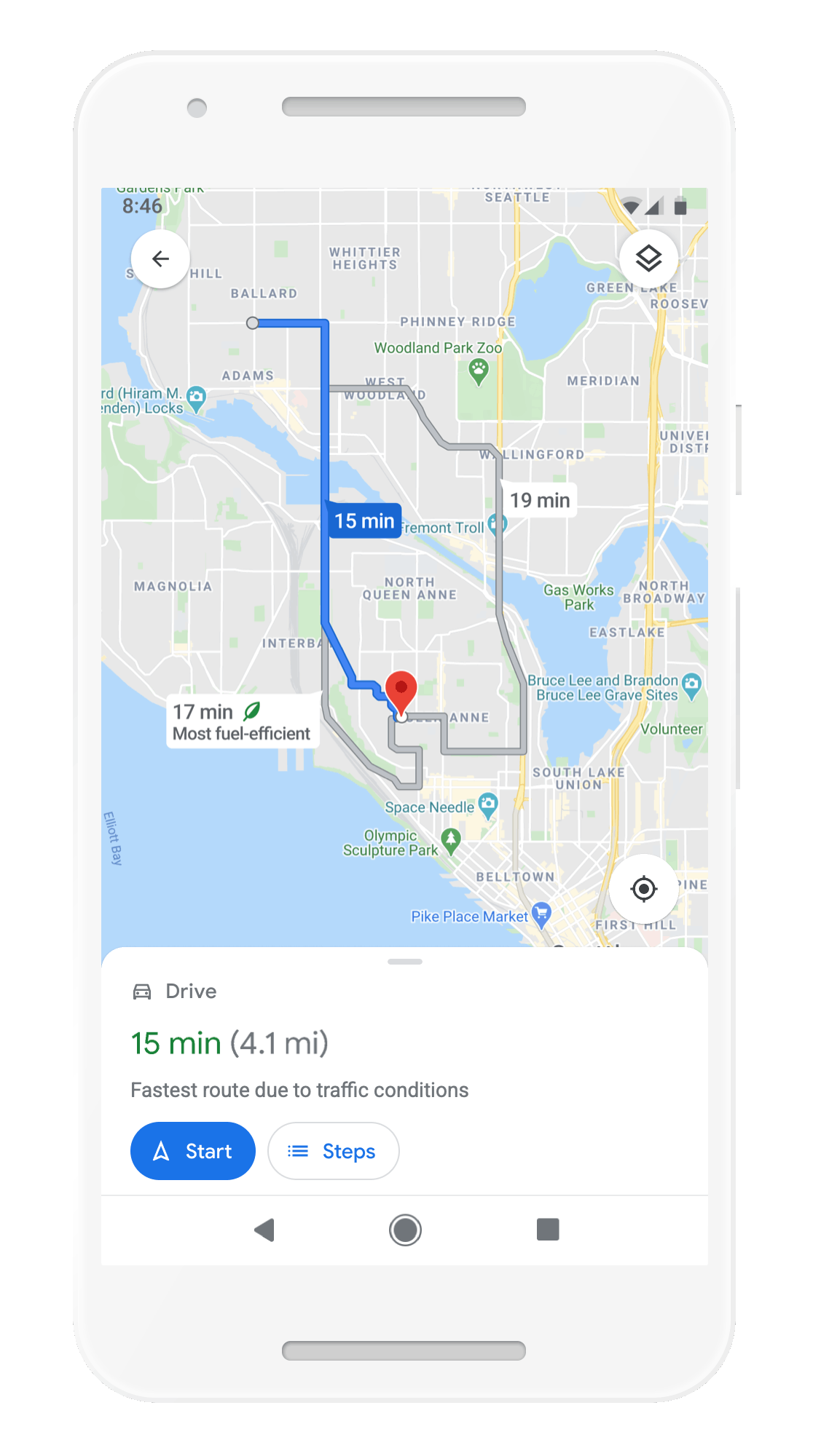
More eco-friendly routes let you choose the route with the lowest carbon footprint
From Amsterdam to Jakarta, cities around the world have established low emission zones — areas that restrict polluting vehicles like certain diesel cars or cars with specific emissions stickers — to help keep the air clean. To support these efforts, Google is working on alerts to help drivers better understand when they’ll be navigating through one of these zones. You can quickly know if your vehicle is allowed in the area, choose an alternative mode of transportation, or take another route. Low emission zone alerts launch this June in Germany, the Netherlands, France, Spain, and the UK on Android and iOS, with more countries coming soon.
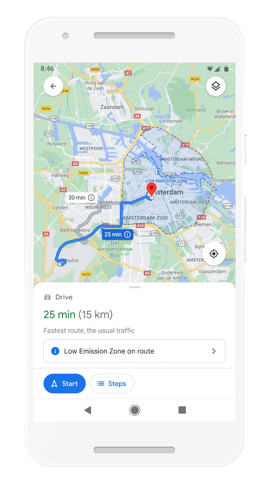
Quickly know if your vehicle is allowed in the area, choose an alternative mode of transportation, or take another route with low emission zone alerts
But Google knows that getting around sustainably goes beyond driving. So Google is making it easier to choose more sustainable options when you’re on the go. Soon you’ll get a comprehensive view of all routes and transportation modes available to your destination — you can compare how long it’ll take to get there by car, transit or bike without toggling between tabs. Using advanced machine learning models, Maps will automatically prioritize your preferred modes — and even boost modes that are popular in your city. For example, if you bike a lot, we’ll automatically show you more biking routes. And if you live in a city like New York, London, Tokyo, or Buenos Aires where taking the subway is popular, we’ll rank that mode higher. This rolls out globally in the coming months on Android and iOS.
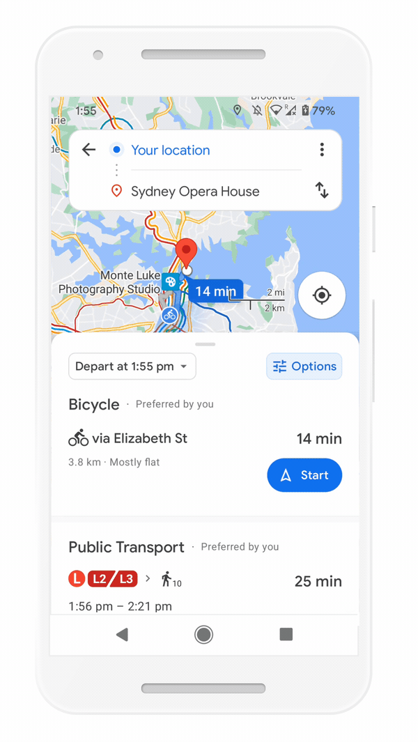
Easily compare different routes and modes of transportation with the new directions experience
Save time with curbside grocery pickup on Maps
Delivery and curbside pickup have grown in popularity during the pandemic — they’re convenient and minimize contact. To make this process easier, Google is bringing helpful shopping information to stores’ Business Profiles on Maps and Search, like delivery providers, pickup and delivery windows, fees, and order minimums. Google is rolling this out on mobile Search starting with Instacart and Albertsons Cos. stores in the U.S., with plans to expand to Maps and other partners.
Check out helpful information about grocery delivery providers, pickup and delivery windows, fees, and order minimums</p
This summer, Google is also teaming up with U.S. supermarket Fred Meyer, a division of The Kroger Co., on a pilot in select stores in Portland, Oregon to make grocery pickup easier. After you place an order for pickup on the store’s app, you can add it to Maps. Google will send you a notification when it’s time to leave, and let you share your arrival time with the store. Your ETA is continuously updated, based on location and traffic. This helps the store prioritize your order so it’s ready as soon as you get there. Check in on the Google Maps app, and they’ll bring your order right out for a seamless, fast, no-contact pickup.

Track your grocery order status, share your ETA, and let the store know you’ve arrived – all from Google Maps
The new AI-powered features will be rolling out over the next few months. Read more at Google here.