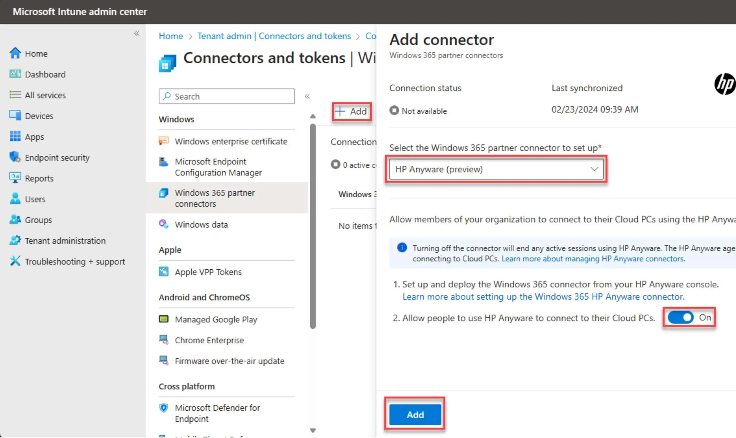
Microsoft To Discontinue AutoRoute, Streets & Trips And MapPoint Mapping Products
![]() 4 min. read
4 min. read
![]() Published on
Published on
Share this article

Improve this guide
Read our disclosure page to find out how can you help MSPoweruser sustain the editorial team Read more
Microsoft has announced their plans to discontinue all of their offline mapping software products in favor of Bing Maps. It includes Microsoft AutoRoute, Microsoft Streets & Trips and Microsoft MapPoint. Since all these are traditional software products, the retirement of these products will not affect software already installed. Current users may continue to use Microsoft AutoRoute, Microsoft Streets & Trips and Microsoft MapPoint to plan their travel adventures and Microsoft will provide online support until at least July 2015.
“The success of these products would never had happened were it not for the loyal and supportive fans who purchased the product and its various iterations over the years,” shares Larry Petersen, test lead for Microsoft Streets & Trips. “Speaking at RV rallies over the years, I’ve loved hearing about our avid customers’ experiences using the software to plan and enjoy road trips across North America. The feedback and enthusiasm from our users have helped make Microsoft travel planning software a leading solution for nearly twenty years.”
Microsoft is now recommending everyone to check out http://www.bing.com/maps/ online or via their PC and Windows Phone 8.1 by downloading the Bing Maps app.
If you are not aware of these products from Microsoft, read about them below,
Streets & Trips 2013:
Find adventure on the open road with Microsoft Streets & Trips. With the #1 best-selling travel and map software, explore new places, generate maps and directions, add your own contacts and points of interest, and even get spoken directions-all without an Internet connection. Let Streets & Trips help you find the adventure—not get lost finding it.
- Updated look and more than 2.5 million points of interest including national parks, casinos, hotels, campgrounds, and so much more..
- Change your plans on the go, with no Internet connection—choose specific roads by dragging and dropping the route.
- Updated maps of the United States and Canada include over 150,000 new miles of roads.
- Personalize your maps by adding notes for planned stops, reservation details, phone numbers, and more.
- Find your way easily with detailed, turn-by-turn directions and an easy-to-read night map.
- Download free construction updates and easily drag-and-drop your route to bypass delays.
You can order it from Microsoft Store here.
AutoRoute Euro 2013:
AutoRoute 2013 includes updated maps of Europe with more than 3 million points of interest and over 9 million kilometers of navigable roads. Spend more time enjoying the adventure and less time trying to find your way to it.
- Updated maps for Eastern and Western Europe: 37 countries covered with 9 million kilometers of navigable roads and motorways
- Routes and directions can be changed on-the-go—no Internet access required
- Choose roads to use on your trip just by dragging and dropping the route
- Includes more than 3 million points of interest including national parks, casinos, hotels, pubs, campgrounds, fuel stops, and much more
- Flexible trip-planning options like custom start times, driving speeds, and rest breaks
- Share trip details such as route information with friends and family
You can order it from Microsoft Store here.
MapPoint 2013 North American Maps:
Microsoft MapPoint 2013 is powerful mapping software that makes it easy to combine business data with mapping and location. Using MapPoint, you can turn complex business information stored in spreadsheets and data tables into easy-to-understand maps. Use MapPoint with your compatible GPS locator to add real-time routing and directions.
- Updated maps of the United States and Canada, new look, and 2.5 million points of interest
- Create sales territories and share performance maps to clearly visualize, analyze, and communicate performance
- Include pushpin images from previous versions of MapPoint
- Combine business data with demographics to find and target potential customers, and focus your business decisions
- Insert maps into the work you do in Microsoft Office, and build custom solutions and Office add-ins
You can order it from Microsoft Store here.
via: Neowin